July 19, 2019
Checking out the latest Hudson River amenity before everyone else does
On a surprisingly pleasant Sunday morning in July, not too hot, we hauled the boats north of Albany to the other side of the Hudson River to check out the shiny new boat launch that the City of Troy had built on the north side of downtown. We had the whole thing pretty much to ourselves, only one other vehicle hauling a boat trailer was parked in the spacious parking lot. That was rather fun, taking our time for a change and not worrying about blocking traffic at the concrete ramp. Of course this underuse will not last, by next year this boat launch will be as busy on weekend summer days as any of the more popular launches in the Capital Region.
The Ingalls Avenue Boat launch was just opened on the last day of this past May. The State of New York apparently really wanted this launch, calling it “a priority site on the Hudson River Estuary Program Boating Access Plan,” and happily provided the funding for the project with a series of grants. First proposed in 2009, it went through several design changes and a slight shift in location southward before construction finally started last year at the end of September.
For us, what’s really interesting and exciting about this new launch is that it provides a view of a teeming section of the Hudson River that we’ve never seen before. You can walk along the river until you know every inch of the shoreline, but 20 feet away in the river is a whole other world you don’t expect or even suspect exists until you actually get in a boat and paddle along the shore on the water. It’s like an alternate reality within easy reach, all you need is a boat and a paddle and a life vest. Don’t ever forget to wear that life vest, even in the calmest water like we had that day.
 The Ingalls Avenue Boat Launch, Dropping The Boats among The Goose Poop
Right away we encountered a problem, there was a large quantity of goose poop all over that brand new pavement. The Wife was much disgusted, gingerly trying not to step in the poops and trying not to drop straps on the ground as she untied her canoe from the car. While we were dropping the boats, a flotilla of geese motored toward the boat ramp, but before they landed they took a gander at us (so to speak) and turned around and headed back out to sea.
 Incoming Flotilla Of Poopers Changing Course
It’s really nice launching our boats at a new facility, most of the launches we go to are pretty beat or even marginal, some little more than mud flats. A few are kept in good shape like the one at Saratoga Lake, but up there they charge you seven bucks per vehicle and is often as busy as rush hour on the highway. The launch in Albany is kept in decent shape and is free, but it too can get mighty busy. In the ten miles between Albany and Troy there are no public boat launches, that’s why the State was so interested in building this new one as an economic development incentive. Socialism!
The concrete slab that descends into the water here at Ingalls Avenue, which is free to the public, has an iron wall alongside it on the river side. That’s very nice protection when launching in rough water or if speeding boats passing by are kicking up waves. Also, it helps protect the facility from ice damage in the winter.
 The Small Boat Launch And Handicap Access Ramp
On the land side of the launch is a long ramp, what we assumed was an elaborate handicapped access launch. We’ve seen these in a few places provided for the rare paraplegic kayaker, they are often a funding requirement. Well, I later found out it was more than that, it’s also supposed to be a paddle boat launch for small kayaks and canoes. I didn’t recognize it as such because I’ve never seen anything like it.
It was only later when we were coming back in that I noticed the end of the ramp had low rollers and rails. I’m always skeptical of anything new that I’ve never seen before, the ramp down to the water looks too narrow and the launch point, well, I don’t know. I guess next time we come here we’ll have to try it, would be nice to be able to launch our boats while not jockeying with pickup trucks backing trailers down the concrete ramp.
 The Wet End Of The Ramp
Because of this year’s lousy weather, too much rain and lingering chill, I haven’t had much opportunity to try out my new kayak. Last month we did a short paddle from the Lansingburgh launch across to Waterford and around Peebles Island where the Mohawk River empties into the Hudson, that’s a fine journey full of interesting things to check out, perfect for the beginner or the first paddle of the season. A week later we’d tried to launch onto Ballston Lake from a miserable narrow mud flat jammed up against the road, but the weather was bad on that lake on that day so we quickly gave up and turned back, grinding through those waves and fighting that current was too much like work.
So this was really only the second time I’ve had a chance to use my new kayak, my old 12 year old tub was getting pretty run down and I was losing confidence in it. I’d hate to spring a big leak an hour from shore on Lake Sacandaga. The new kayak is the same as the old one only it’s the latest model with improvements, plus it looks rather snazzy. This was a gift from The Wife, she handed me several cash endowments toward a new boat over the last few birthdays and Xmasses, and we finally bought it in May at Mountainman Outdoor Supply in Old Forge up in the Adirondacks. I highly recommend that place if you don’t mind the trip.
 East Side Of The Federal Dam and The Lock House
Immediately North of the Ingalls Avenue launch is the Federal Dam which was finished in 1916. (Or 1915 or 1917, depending on the source.) It was built by the US Army Corps of Engineers to improve navigation on the river, thus the name. Socialism! On the East side of the dam is a boat lock that lifts boats 14 feet. If on a future trip we decide we want to go north past the dam we most certainly can lock through. The cost for locking through for all “pleasure boats,” which would include our little motorless floaters, is no charge. All locks in the State are free to non-commercial craft, no matter how small.
The Hudson River is tidal and a bit salty (or so I’ve heard, I’ve never dared to taste it) and when the tide comes in the river currents flow north. That is, until the water hits the Federal Dam. The water is higher on the north side of the dam, but it’s not always at a consistent depth due to the vagaries of the Mohawk River that flows into the Hudson to the north at Waterford. Because of that, in the past I’ve erroneously thought that the river was tidal above the dam.
South of the dam the Hudson is unquestioningly an international waterway. This means that according to the US Constitution the shore along the river is public, any citizen can walk along it and no one can claim the shore as private property. Socialism! Most importantly for us, that means we can land our boats anywhere we damn well please if we feel like we need to stand up and massage our sore butts.
 Boats Exiting The Federal Dam Lock
As soon as we launched our boats we ran into a traffic problem. The lock next to the dam had just opened and a line of boats emerged, the boat channel running right past the launch and straight into our little boats. Horns wailed all over the place telling us to get out of the way, as if we had no business on the river. We scooted out into the middle of the river, but I can see this becoming a serious problem when the Ingalls Avenue Launch gets a lot more use in the near future. Should be some interesting controversies, funny how no one considered this problem when the launch was being planned.
On the west side of the dam is a hydroelectric plant, which was commissioned to be built almost 100 years ago by Henry Ford to provide power for his company’s car parts manufacturing plant nearby. The story goes that he was “camping” nearby with his friends Thomas Edison, Harvey Firestone and John Burroughs, a hunting and fishing trip that involved a caravan of Ford’s autos to carry the tents and supplies and servants. He observed the dam and decided to buy up about half of what is now the village of Green Island and petitioned the US Congress to grant him exclusive rights to build and own an electric generator powered by the dam.
 The Federal Dam Hydroelectric Plant
In 1988 the Ford Corporation shut down their Green Island manufacturing plant, moving operations overseas so as to break the domestic unions and undermine the US economy. Today the hydro plant is overseen by the public Green Island Power Authority (GIPA) which allows village residents and businesses significantly lower electricity rates than the main privately owned power provider for the region. Socialism! Because of this amenity Green Island has not gone into a tailspin decline as has happened to so many other upstate New York communities after their main employer bugged out, new businesses have been attracted to the community for the lower rates.
Here we see once again how privateers exploit taxpayer funded infrastructure projects for their own gain. The Federal Dam was built to control water levels and facilitate navigation, not to provide electricity for Ford’s exclusive profit, he would never have built it for any reason. And long after Ford’s corporate descendants tired of using the dam, it is the governments that have stepped in and maintained the discarded power plant for the benefit of the community. And as we observed on this trip, Green Island, the smallest incorporated village in the State, is undergoing an unprecedented expansion of housing.
 The Willow At The North End Of Stomy Island
After inspecting the dam we turned south and quickly encountered what the maps call Stomy Island, but some references call McGill Island. It’s prone to flooding and thus covered with trees and appears to be uninhabited. We saw power lines across the island but not much else. It being low tide we could see a lot of good landing spots, I’m thinking it might make a nice picnic spot on a future boat trip.
The Wife was irrationally spooked by the narrow, shallow channel that separates Stomy Island from Green Island, an overgrown shoreline along a densely populated community that was invisible to us. Green Island, by the way, is no longer an island, it was connected to the rest of North America when the also narrow channel that separated it from the land was filled in during the 1970s when highway 787 was built. There’s a reason why 787 is unstable and needs constant rebuilding, most of it is built on floodplain mudflats and on fill such as this.
 Green Island Neighborhood
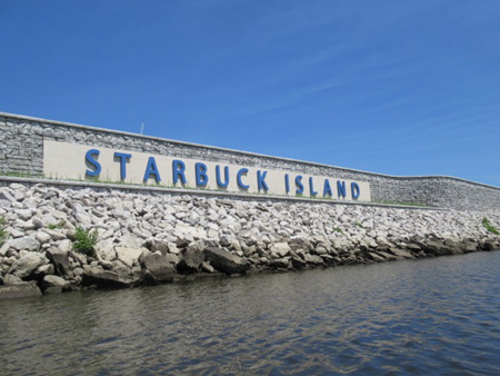
But Stomy island is small and soon we were passing under the Route 7 Bridge which sits on the north end of the next island we encountered, Starbuck Island. On our right, the west side of the river, the brief illusion of being out in the wilderness vanished as the houses of Green Island became totally visible. Here where the river bank was not overgrown we could see how densely populated is this village.
To our left we could see the massive construction project on Starbuck Island, which is part of the village of Green Island. The construction is quite visible to anyone crossing the Green Island Bridge which straddles the island and feeds traffic into downtown Troy. From our boats we were privileged to observe the new construction from below.
 Upscale Apartments Being Constructed On Starbuck Island
It has gone by several names, but it turns out that Starbuck is a revival of the oldest European name for the island, chosen by the developer of the project to be the name from now on. The Wife, of course, wanted to know if we could get coffee there. Until recently the island was a dismal run down industrial zone with unused oil tanks and languishing businesses, after some soil remediation it is becoming covered with residences for the first time ever.
These apartment buildings look like somewhat fancier versions of the same four story or more “stick construction” projects that are springing up all over the Capital Region in both the Cites and in the suburbs. These are preferred by developers because they are quick and cheap to build and return maximum profit. These particular buildings appear to be surrounded with parking lots, which makes the new project a virtual suburb plopped down in between two dense urban communities.
The project is being advertised as a “gated community” which means the entire island will become a fortress that does not allow access to anyone who is not authorized to visit, you and I won’t be able to just walk around there and look. We noted the wall that now surrounds the entire island. No doubt it is there to prevent floodwater and winter ice from slopping into the parking lots, but also makes it difficult for someone like us to land a boat and go walk around. In effect, it is a defensive wall and the river serves as a moat.
 On The Troy Side Of Starbuck Island
Rounding the island and heading north again with Troy on our right, the defensive wall became fancier and displayed the brand. In front of the wall on the shore the builders have placed a very impressive ring of riprap composed of sharp boulders, again while this prevents erosion this also makes it nearly impossible to land a boat of any kind along the shore. In this way they get around the Constitutional injunction against closing off international waterway shorelines to the public.
Just past the brand name sign that faces Troy is the only river access point provided for the future residents of the island. Naturally it is a high platform that does not allow one to descend to the water, nor does it allow one to launch or land a boat. Personally, if I considered living on an island in the middle of the river I’d want a boat launch, the only way on or off the island is by the onramps to the bridge.
 Construction Visible In Downtown Troy
Large swaths of Downtown Troy are undergoing major rebuilding, this is especially true along the waterfront, which we could see. Part of the idea is to “reconnect urban communities to the river” which has been a planning mantra finally being put into action in this section of the upper Hudson, the new boat launch at Ingalls Avenue being part of that thinking. While critics have rightly complained that the outlying neighborhoods of Troy are being neglected by this building boom, it is important to note that the downtowns of the Capital District, such as Troy, have been intentionally neglected since the middle of 20th Century and are in dire need of rebuilding.
That intentional neglect, driven by the suburbanite mindset of planners and civic leaders, caused the north end of downtown Troy to become almost completely abandoned by the end of the 20th Century. Exactly 20 years ago a group of citizens concerned about food quality were allowed to start an open air farmer’s market, the City gave them a miserable unused parking lot located in the middle of this abandoned section. With an emphasis on locally produced natural and organic fresh food sold directly by local farmers and small producers, the Saturday morning Troy Farmer’s Market quickly became massively popular.
Within a few years the empty storefronts around the farmer’s market began to attract small businesses that wanted to take advantage of the cheap rents and the sudden influx of people looking to buy stuff at the market. The Troy civic leaders noted this (to their eyes) magical transformation of a dead part of downtown, so when the market began to outgrow the parking lot they moved it into the heart of downtown, closing off the streets to auto traffic on Saturday mornings in warm weather and in cold weather moving the market into the otherwise useless and mostly unused Atrium Building on Fourth Avenue. Socialism! The market continues to spread across downtown, a weekly festival and economic engine, while the north end of downtown continues to rebuild and transform, thanks to the market.
 Green Island Bridge
Continuing to head north we passed under the Green Island Bridge, which can swing open for tall boats. We didn’t bring our sketchbooks so it didn’t draw for us. This is actually the third bridge at this location, the first was a wooden covered railroad bridge built in, believe it or not, 1832. That bridge caught fire and collapsed in 1862, a new steel railroad bridge was not ready for use until 1884.
That bridge held up a long time, only in 1962 was one side of the bridge converted into a roadway for cars, which had to pay a toll. But in 1977 river ice caused that bridge to collapse spectacularly. This new drawbridge is impressively solid looking and is for cars and pedestrians only, not more train tracks. It’s hard to imagine Troy or Green Island without this vital bridge, but before 1981 when this one opened for use the communities did without it.
 Unused Barge Dock Off Starbuck Island
Paddling north back to the boat launch I spotted this iron covered concrete block near the south end shore of Stomy Island. Once upon a time this river was one of the busiest highways in America and boat parking was at a premium. You can see these abandoned structure sticking out of the water up and down the river where one could tie up a barge without running aground, perhaps barges unloaded on this island.
 Mysterious Derelict Water Intake Valve
Also we spotted this odd structure, which appears to be an old derelict water intake valve. I’m speculating that this was put here sometime in the middle of the 20th Century for some long gone industrial concern that was located on flood-prone Stomy Island, which is surprising in itself, hopefully for some manufacturing process and not for drinking and washing. Today it would be nigh on impossible to locate an intake like this out in the water, besides being an obstruction it’s hard to imagine what justification for having such a thing would go on all the permit applications.
 Aerial Drone View Of The Ingalls Avenue Boat Launch
A criticism of the new launch is that is designed to facilitate vehicles pulling trailers, when it gets busy the cars will line up on the approach roadway and only back into the launch (two at a time) when it is the next person’s turn. This is good auto traffic management but makes it very hard for small boats on car rooftops to untie and launch on busy days. There is that launch for small boats off to the side, which I repeat does not look very user friendly, but there is no place for cars to park to use it without interfering with trailers using the ramp.
And a big complaint I often cite, the concrete slab descending into the water is too steep, which may be desirable for very large boats but is troublesome for any small craft, with or without a motor. The next weekend I tried to land my boat on a similarly steep slab and managed to spill myself out of the boat in front of a whole bunch of people. And there ought to be a direct path from the launch to the parking lot, rather than walking the long way around via the roadway I had to climb over a grassy berm and down a steep hill.
 The Narrow, Shallow, “Spooky” Corridor Along Stomy Island
But our culture is oriented around motorized vehicles, we certainly couldn’t access this launch without a car to carry our boats up from Albany. So we paddlers have to adapt to these little indignities, although it would be nice if the planners gave us some serious thought for a change. We paddlers don’t emit much carbon and don’t spill any oil on the water (which all motorized boats do), we are very much the eco-friendly alternative and deserve a little consideration.
Oh, and The Wife wants restrooms at the parking lot. A port-a-potty will do. She doesn’t care to hide in the bushes to do her business after we land, which is probably illegal so maybe she didn’t. But she doesn’t want to have to expose herself to the snakes and the poison ivy and the bugs when she has to go, hypothetically speaking of course. That’s an improvement the City of Troy could easily provide.