August 31, 2016
From the South End of Albany all the way to Voorheesville, okay not all at once but we did the whole thing
It seems like every few days I hear or read about more people discovering the Albany County Helderberg-Hudson Rail Trail for themselves and offering praises and delight. Actually, most of the trail outside the City of Albany has been open to public use for quite a few years, sorta kinda kept clear and maintained by other municipalities. What’s new this year is the development of the trail from Albany to Delmar, the trail surface paved with asphalt and the old railroad bridges on the trail repaired.
Without question, this newly opened part in the City of Albany is the best laid out and most interesting part of the Rail Trail. Right now we have the best surface for walking or riding bikes, and we have the most interesting things to look at on either side of the trail, and absolutely the most spectacular views. I can say this because yes, The Wife and I have walked the entire length of the trail from Albany to the foothills of the Helderbergs and seen it all.
But we didn’t do it all at once. Without planning this turned into a summer project, three different journeys on three different sections of the trail on some of the hottest afternoons in July and August. Maybe we shouldn’t have ventured out into the midday heat like that, but we both survived the ordeals.
 The Normanskill Under The I-90 Bridge Seen From The Helderberg-Hudson Rail Trail In The City Of Albany
It was a very hot Fourth of July when I decided to take The Wife for a walk on the Albany part of the trail. We’d been talking about bicycling on the trail since May when the Albany part officially opened, but to tell you the truth I’m not big on bicycling like The Wife is and my old bike is not in top shape right now so we never quite got it together. But I like walking because you can stop and see so many things that you just miss when you go whizzing by at top speed or panting mightily as you peddle up a long incline.
We had a hell of a time trying to find the shiny new parking lot on South Pearl Street where the trail currently begins. There was no signage, and the County website, among other sources, helpfully told us in detail how to access the newly opened trail from several places in the suburbs but didn’t bother to tell us how to find the trail in Albany. I chalked this up to typical tiresome suburbanite discrimination against my community and we proceeded to search for the trailhead.
 The Hard To Find Parking Lot At The Trailhead On South Pearl Street In The South End Of Albany
About six years ago during a muddy spring day The Wife went on a hike on the future rail trail with a few trail advocates, this at the urging of our then Albany County legislator Luci McKnight. The route was mighty rough at that time, punctuated by half buried decaying railroad ties and overgrown with brush.
We had an argument because The Wife recalled accessing the old railroad corridor from a private parking lot behind some warehouse and bushwhacking through a typical South End wooded section to find the railroad embankment. I kept telling her this couldn’t be it, I’d heard there was a new designated parking lot and besides, forcing people in Albany to push through underbrush was too discriminatory even for suburbanite planners. I mean, they would have to consider legal liability.
Eventually we found the parking lot, more or less across from the Cherry Hill mansion to the south. My thinking that bright, swelteringly hot day was to find some nice shady place with trees to take a walk. In this the trail turned out to be congenial enough in Albany, providing tolerable shade in the midday heat.
 Pleasantly Shady In Albany
It being a holiday we passed a lot of other people walking the trail, many from Albany, almost everyone was happy and greeted us as we passed. But the bicyclists that passed us coming from Albany had to struggle up a long gradual incline that runs all the way to the border of Albany. That incline, we discovered, becomes even more gradual as you leave Albany but continues to rise almost to Voorheesville.
Shortly after the start of the trail we could see on one side the rooftops of Old South Pearl Street, a neighborhood hidden in the woods on what is now a dead end. On the other side we had a lovely view of the crumbling parking lots behind the recycling waste facility, which may not be too attractive but I found fascinating. I hear there are plans to develop this back lot either with some sort of light industrial or by expanding the recycling facility.
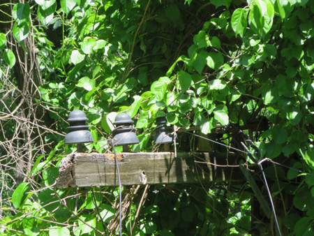 Old Powerlines Overgrown
After that the scenery ranges from pleasant to spectacular. Enough trees had been left close to the trail so that as we walked the blasting sun was regularly interrupted by shady spots. We passed by some rock outcroppings that had been cut back when the railroad was built, rising well over our heads. On either side of the path I spotted remains of the signaling system for the trains, concrete pedestals and old electric lines and such.
All along the trail I observed the embankment we were walking on with wonder and admiration. The trail has only the gentlest of curves in Albany and beyond that is mostly straight as an arrow all the way to Voorheesville, rising slowly and steadily without one single dip or hill for the trains to deal with. In many places the sides of the embankment go down deep into valleys on both sides, and in others, such as at the carved rocks we passed, the hilltops had been cut through probably by chipping them with hammers and spikes because dynamite hadn’t been invented yet.
 Rock Outcropping In Albany, Probably Cut By Hand
All of this impressive earthmoving had been done by hand, there were no bulldozers or backhoes back then. I tried to imagine the swarm of underclass laborers who built the embankment with shovels and picks, all this dirt and stones moved by carts drawn by horses and oxen, probably a massive spectacle to see as it was constructed. It was laid down so carefully and precisely that after 150 years the roadbed is still in such good shape that you could lay another set of tracks on the bed tomorrow and run trains safely.
This train line, believe it or not, was opened back in 1863 as the Albany & Susquehanna Railroad (A&S) that ran from Albany across the Helderberg Mountains past Altamont and continued south to the major train hub at Binghamton by the Pennsylvania border, some 143 miles. This first part, the run from Albany to Schoharie, took 12 years to build. Consider that this train line was opened for service a mere 32 years after the first passenger railroad was built in the Western Hemisphere, the tenuous and decidedly low-tech Dewitt Clinton (which ran through my neighborhood a short half block from my house.)
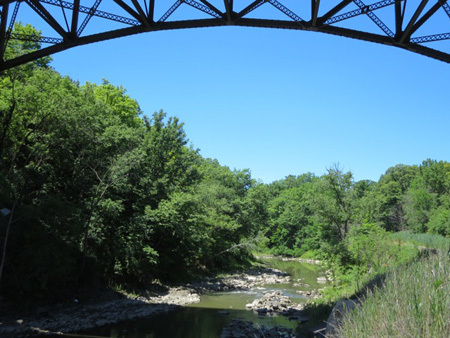
 The Normanskill Rushing Over Rocks
This train line was so important and so profitable that in 1869 competing robber barons, JP Morgan on one side and Jay Gould and Jim Fisk on the other, fought each other as both attempted to take over the smaller and more vulnerable A&S. At one point the owner of A&S tried to stop the predators from buying up shares in his company by burying the company’s books in Albany Rural Cemetery. At another point armies of thugs hired by both robber barons commandeered trains and rammed head-on into each other inside a tunnel located about 16 miles east of Binghamton at Harpursville, after which the thugs on both sides jumped out of their wrecked trains and engaged in a pitched battle. By the next year Morgan won effective legal control of A&S, although A&S continued to exist on paper until 1945.
The train revolutionized local travel and movement of goods, the run from Albany to Voorheesville was a mere 19 minutes, faster than by auto today. But passenger service was suspended in the 1930s, probably to force people to become more dependent on autos, a national trend at the time. In 2003 then owners Canadian-Pacific officially abandoned the 11 miles from Albany to Voorheesville, selling the right of way to Albany County in 2009 so that the County could make it a walking and biking trail, but also with the intention of preserving the railroad right of way for some future transportation use.
 The Albany Rail Trail, 2016
The upper half of the trail in Albany runs alongside the Normanskill, which is the border of the City with the suburban town of Bethlehem. In spots the river is placid and stagnant looking, but at other sections it rushes over craggy rocks and presents the kind of spectacular vistas you would expect in the Catskills or Adirondacks. That’s the City of Albany for you, parts of it look and feel like you’re in the middle of New York City. But then you can travel a short distance and you are surrounded by near wilderness like this, never leaving town.
 The Rail Trail In 2010, Compare With The Photo Above
When The Wife surveyed the trail back in 2010 it looked a whole lot different than it did now. Decaying tracks were buried in the roadbed, and in places there were piled up obstructions. But the path was clear and stable, other than the beds of the bridges there was no serious structural work to be done.
 The Suspension Bridge Over The Normanskill In 2010
We eventually came to the suspension bridge over the Normanskill at the City line. The bridge has remained sound and steady since it was built before the Civil War, but the deck had become a crumbling hazard. Six years ago The Wife, who is terrified of heights, refused to cross the bridge with her hiking companions, but she took some good photos.
 The Normanskill Bridge Today, 2016
I was interested to see that the Normanskill Bridge had not been carefully cleaned up and painted other than a quick graffiti removal and wire brushing. After 150+ years in the rain and snow it needed minimal work. The metal must be some sort of very high quality alloy. All of the trail gave evidence of quality original construction, I would guess the idea was that the road had to be totally reliable and damn the cost.
I noticed that the wooden surface built on top of the old bridge was held together with joints so sections could move up and down as the metal bridge moved underneath. You see this on the colossal Mid-Hudson Pedestrian Bridge at Poughkeepsie, an old railroad bridge which was designed to sway in the wind. I will be interested to see how long the new wooden platform lasts, it’s pressure treated with copper sulfate but is unpainted.
 The Rail Trail In Delmar, Nice But Not Much Shade
So we continued strolling through the sun-blasted midday heat toward Delmar in the Town of Bethlehem. Here there was very little shade, the trees had been cut way back from the path. We had only brought a couple of water bottles with us and The Wife was starting to make complaining noises.
Fortunately the trail runs right through the heart of Delmar, which has a fairly compact urban center in the middle of surrounding suburban sprawl. We exited the trail not far from Delaware Avenue, and even though it was a holiday found a bar and grill open on Delaware called My Place. I’d never been there before, they have good burgers for a low price and we drank a lot of liquid and enjoyed the air conditioning.
 The Horrifying Eagle Of Death Atop The War Memorial In Delmar
Soon we got back on the trail and headed for the other side of Delmar. Part of the trail has been in use for several years, maintained by the village. Notably the trail runs through War Memorial Park which must have been a much different place when the trains were running. Today it’s a grassy spot with sitting benches around a granite memorial topped with the most terrifyingly horrible depiction of an eagle I’ve ever seen.
We continued past Four Corners in Delmar, but admittedly we didn’t quite make it to the end of the paving trail where Slingerlands begins because The Wife was losing it and demanded we turn back. Later we drove to the spot where it ended to discover that we had almost made it. Instead we trudged downhill back to South Pearl Street and then drove the car to have ice cream at Emack and Bollios on Delaware Street in Albany.
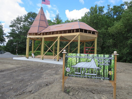 The New Pavilion At The Other End Of The Rail Trail In Vorheesville
The very next Saturday we drove out to Voorheesville to walk the other end of the trail. Heading up into the hills to Altamont and beyond, freight trains are still running along the right of way. Only the tracks from the rail hub of Voorheesville to Albany were abandoned. I wonder if Canadian Pacific Railway regrets their decision, they sold their run to Albany just as demand for rail service to Albany for tank cars carrying fracked Bakken crude oil began to overload local tracks.
The trails starts on one side of the village of Voorheesville, another small urban center surrounded by suburban sprawl but also by small farms. The trail here, which appears to have been maintained by the village, starts on one side of the community. It wasn’t quite as terribly hot of a day with puffy clouds and a breeze, but we were pleased to find this part of the trail was decently shaded.
At the beginning of the trail a pavilion is being constructed, which appears will remain open sided and will probably be full of history or something like that. According to a historical marker nearby this was the site of a tourist destination in the late 1800s called the Grove Hotel (actually the Friar’s Grove Hotel.) Like the train station that was once located across Grove Street, it is long gone.
 The Rail Trail Becomes One Rut As You Head Away From Vorheesville
The Rail Trail near the village started out paved, but turned to gravel and then disintegrated to two ruts or sometimes one rut as we headed out. It turns out the ruts were probably made by the large number of bicycles that passed us, clearly this section turns into a big mud pit when it rains. That problem will be solved soon, the County has taken over the entire trail and this part is scheduled to be paved in 2017.
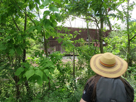
Our goal that day was to walk to the enormous Hilton Barn built in 1898, which was moved this past March from the old LeVie Farm at the corner of Routes 85 and 85A to this present site a short distance away on Hilton Road next to the Rail Trail. The barn is 120 feet long, 60 feet wide and 60 feet high at the peak and is said to be the largest post and beam structure ever built in Albany County.
 The Enormous Hilton Barn On Its New Foundation
It had been jacked up off it’s original foundation, had I-beams clamped underneath, and the I-beams with the whole structure on top of them was placed on a big truck bed and rollers. Electric wires and cables strung on the poles along the road had to be taken down for the move. The move and preparing the new site cost about $150,000, half of it paid for by County taxpayers.
We found that the barn had been placed on a new concrete foundation at the new site. The wood is much decayed at the bottom of the barn, which in itself makes the move a wonder. But the structure is sound enough, it survived the trip without shaking apart. It’s sitting all open with the I-beams still in place. And no, we did not climb inside the barn to look around, we could see pretty much everything from outside.
The backstory about the barn is that back in the 1990s the 179 acre LeVie Farm was sold to a fellow who wanted to build a massive shopping center on the corner of 85 and 85A. A large number of New Scotland residents opposed the unneeded project, their successful effort to delay the construction was centered around preservation of the barn. The owner of the land was enraged at being thwarted, he publicly vowed to let the barn disintegrate, demolition by neglect.
 Moving The Hilton Barn Across The Road Last March
Around 2008 the New Scotland town board approved construction of a 1.5 million square foot big box retail center on the site, which is said would have been the fourth largest shopping center in this State. But then an amazing thing happened. The citizenry organized into a group that called itself New Scotlanders 4 Sound Economic Development, and collected signatures on a petition from almost a third of the town residents to oppose the project. "This is not an issue about no growth," said a spokesperson for the group. "This is an issue about sound growth and planning."
The group charged that the town board, which was composed of both Republicans and Democrats, was being bought off by the developers, for which there is some evidence. They also charged the board with deliberately shutting out the taxpayers from having input on the decision, which was a fact. The group ran a slate of both Democrats and Republican insurgents in the 2009 election under the name “New Scotland FIRST” and successfully ousted the old boys and girls of both parties from the board. It was amazing to watch and was not reported properly by the local Corporate Media while it was happening.
The developers, reading the inevitable situation, left town shortly before the election. In 2012 the new town board created a master plan with wide citizen input. This current plan calls for a “traditional village development” on the LeVie Farm site with sidewalks, bike paths, houses and apartments close together, with small retail outlets and a “large town commons.” Right now plans are being developed and the old commercial zoning designations are being replaced.
 Looking At The Hilton Barn From The Rail Trail About Where An Access Bridge Will Be Built
But the barn was not forgotten, that is why it was moved across the road next to the Rail Trail by Albany County. I’ve heard various plans for it, a museum or retail shops or an educational center. That’s up to the County and the Town of New Scotland. The idea is for it to be adjacent to the new integrated community to be developed across the road, and to be a desirable destination for anyone traveling the Rail Trail.
We walked back to Voorheesville and drove across the village to Smith’s Tavern for a late lunch. There were reports earlier this year that this venerable landmark was going to close and be replaced with a Stewarts shop, this because the owners are ready to retire. But the waitress told us nothing was certain, Stewarts had not made a commitment and the elderly owners were still hoping to find a buyer and keep the old place the way it’s always been. The food there is still pretty good.
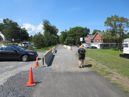 Where The Pavement Ends In Delmar: The County Takes Possession
It wasn’t until the last weekend in August, another blisteringly hot day like the Fourth Of July, that we finally walked the last part of the trail between Delmar and Voorheesville. It turned out to be a shorter stretch than we thought it was, about 3 miles. It starts at the tollgate intersection at the border with Slingerlands, so called because a long time ago Route 85 was a privately owned toll road and this is where the tollgate was located.
This section is far and away the shadiest part of the Trail, sections of it were like tunnels of green which we much appreciated. Other than some nice views of fallow fields of wildflowers through the trees there were not many exciting things to see, and the roadbed was also rutted, but this too will be paved next year. The real excitement was right at the beginning at the Delmar line near the old tollgate.
 The Privately Owned Railroad Freight House
There is an old train station there, a freight house actually, that is now a private home. The owner of the house considered the Rail Trail that runs on one side of the house where the train tracks were located to be his personal property. He considered anyone who used the Rail Trail next to his house to be trespassing, so he tried to block off the trail.
The County was not amused, so they took possession of County property by dropping jersey barriers alongside the Trail along with a bunch of orange cones. In addition, the County says the guy doesn’t own the land underneath the old rail house, he was supposed to pay the County rent for the land but hasn’t paid a dime since 2009. So now they are threatening to take the building away from him and dismantle an addition that he had added which encroaches on the Rail Trail. Wonder how that turned out.
 View From A Train Window In Slingerlands
We walked up the gradual incline until we got to the Hilton Barn in Voorheesville. I tried to get The Wife to walk the extra few miles into the village so we could visit Smith’s Tavern again, but part way there she began to complain miserably about the midday heat. So in an attempt to stop the whiney noise I acceded to her wishes and we trudged back the way we came toward the car we left in Delmar.
 Shady Tunnels Of Green In This Section
About halfway back we chatted with a model suburban family strolling past us towards Voorheesville, Dad, Mom, kids and a dog. We told them we’d now walked the entire trail, which they found impressive, and then we told them we lived in Albany and they should hike that part of the trail soon. At the mention of Albany the faces of the adults immediately changed, we both could see them thinking “Albany is an icky place full of icky people and if we go there drug addicts will eat our dog and force our children into prostitution.”
Even though she was out of it from the heat, The Wife noted their facial expressions and swung into immediate action. She said, “You really should check it out, there’s a brand new parking lot at the trailhead. The trail is newly paved and easy to walk on, it’s the best part that we’ve seen. It has the most spectacular scenery I have ever seen on a walking trail anywhere.” They all looked surprised, and said We’ll have to check it out, thanks.
After they were gone I said to her, The most spectacular you’ve ever seen? She grumbled, Yeah well I haven’t seen a lot of walking trails. I didn’t argue much. When finally we got back to where we started, we sat for a while at a booth inside Tollgate Ice Cream, which has been at the tollgate intersection since 1949 when that area was outside the settled areas and not surrounded by houses. The ice cream is real good, and the air conditioning worked fine, so we recovered from the heat nicely.
 The Toll Gate